Tags: Infocenter

Guanacaste Traveler’s Tips

Costa Rica is a beautiful country and Guanacaste is one of the safest areas for tourists in the country, but just like every other country in the world, Costa Rica faces the challenge of staying safe and achieving security for its citizens and visitors. By taking just a few precautions, you can avoid possible risks.


If you are renting a car

  • Always follow traffic signs, especially the speed limits.


  • Never leave luggage or other belongings in sight in the car if it is unattended.


  • Keep doors locked and windows closed while driving or parked.

  • Avoid stopping when a stranger asks for a ride.


  • If you are lost or need to check your map or ask for directions, find a public and safe place to do it.

When using a taxi service

  • Always ask an employee of your hotel to get you a taxi from a reputable company.


  • Verify that it meets the legal requirements, such as the yellow triangles on the doors and the taximeter on the front.


Traveling in bus

  • Plan your trip in advance, especially your transportation from the hotel to the airport.

  • 
If you plan to sleep while traveling by bus or any other means of transportation, keep your belongings close to you.

  • Do not rely on someone who is very friendly, keep in mind that it could be a distraction while somebody else robs you.

  • Police officers are available to help you, in case of an emergency call 911.


  • Our currency is the Colón.

  • The exchange rate varies slightly from day to day.


  • Use only banks or authorized exchange booths to change your money. These transactions require your original passport. 

  • Use ATMs located in safe, well-lit places.


  • 13% sales tax is always charged on the price of items you are buying. In restaurants and bars there is a 10% tip. An extra tip is optional but it is a frequent custom.


  • Buy only from established suppliers (car rental companies, tour operators, etc.) They can provide you adequate security and support if needed. 

  • 
Keep an eye from people offering services on the street. They can be scams or unsecured informal services.

  • Always ask for a bill with the details of your purchase.


  • Always ask for an explanation of the cancellation policies of the company before paying.


  • Always ask local people about rip currents, waves, weather or dangerous animals on the beach you visit.


  • Watch for sea or river conditions. Muddy water can mean dangerous currents or a head of water.

  • 
Avoid swimming alone.

  • Remember that some rivers and beaches are inhabited by crocodiles. Avoid swimming in estuaries or in rivers you don’t know.


  • If you like water sports, practice them only with certified companies.


  • 
Leave your values in the safe of the hotel (passport, airline tickets, reserve money and credit cards, etc.)


  • Keep your wallet with you in a safe place out of sight.

  • Be always alert and aware of what happens around you. We suggest not to use fine jewelry and not to carry large amounts of money with you.

  • 
Leave your room key at the front desk when you leave.
 

  • Never let a stranger get too close to you under no circumstances; it could be a robbery attempt.  

  • If harassed by a hostile individual, do not resist and do what he asks. Your belongings are not worth your life.


  • If your credit card gets lost or stolen, cancel it immediately.


Forecast for Guanacaste, Costa Rica

  temperature°CPrecipitationWindHumidity

Flights schedules for Liberia Airport (LIR) in Guanacaste.

(Real-time update)

Arrivals to Liberia Airport (LIR) in Guanacaste. 

Flights status are updated every minute. Simply reload this page to update. 

Daniel Oduber Airport (LIR) Telephone: 2668-1010

Departures from Liberia Airport (LIR) in Guanacaste.

(Real-time update)

Flights status are updated every minute. Simply reload this page to update.  

Daniel Oduber Airport (LIR) Telephone: 2668-1010

Flight information is provided by FlightStats, and is subject to the FlightStats Terms of Use. 

National parks of Guanacaste


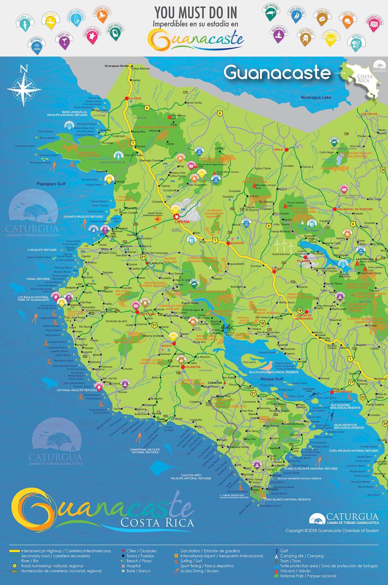
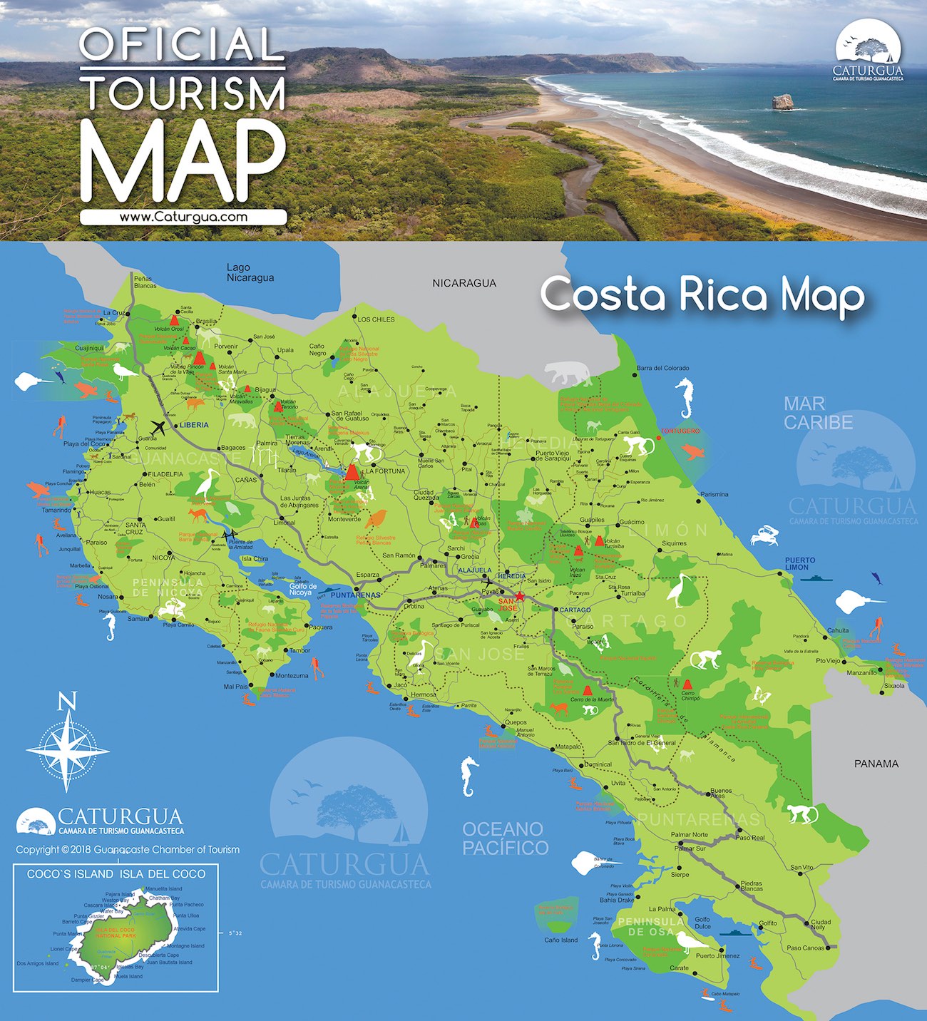
Costa Rica is worldwide known for its efforts to protect the biodiversity of flora and fauna on its territory. More than 25% of the territory of Costa Rica consists of national parks and protected areas. A good part of them are in Guanacaste.


Barra Honda National Park

Barra Honda National Park will surprise adventure and natural beauty lovers. Its network of limestone caverns is decorated with rock formations, thanks to the action of water on calcium carbonate. Although only one of the 19 explored caves is open to the public, it is more than enough to find a unique treasure. Descend over 20 meters to start discovering an unforgettable underground world that will leave you with your mouth open. It is also a special place to walk through the dry forest and be charmed by the beauty of the natural scenarios you can enjoy from their viewpoints.

  • Schedule: 8:00 a.m. to 4:00 pm for regular tours and from 7:00 am to 1:00 pm to get down to the caverns.

  • Rate: ¢600 for locals and $ 6 for foreigners. The rental of equipment for the cavern and guide service has an additional cost

  • Access: Gravel road with some difficulty for small vehicles during the winter.

  • Routes: From La Amistad Bridge 31 kilometers to the entrance to the village of Barra Honda and 10 kilometers to the park. Another option is 13 kilometers from Nicoya, until you find the entrance to the village of Barra Honda, after that, the signs will guide you.

  • Services and facilities: Camping area, guide services and caving equipment, food, accommodation, parking, drinking water, public phone within 3 km, radio and tourist information.


Rincón de la Vieja Volcano National Park

The lush primary dry forest that characterizes this park is home to thousands of species of orchids and diverse ecosystems that host around 300 types of birds like the great curassow, the turquoise-browed motmot, black-faced solitaire and toucanet, as well as several mammals such as the mountain goat, the peccary, the agouti, the tayra, armadillo, northern tamandua, two-toed sloth and howler, white-faced and red monkeys.

But the biggest attraction in this park are the pailas: silent boiling fumarolic lagoons amid the premontane forest, trying to go unnoticed, but at the same time, letting their plumes call the attention of visitors.

This amazing haven of peace and tranquility is divided along paths that lead to the pailas and even the volcanic cones through a path where you will see the most active, volcanic mud baths, geysers, caverns, natural saunas, steam baths and pools of hot water in the country.

The Santa Maria crater is inactive and overgrown, and it is the highest point at 1916 meters above sea level.
The park protects and preserves watersheds that supply water to the city of Liberia. It hides a surprising wonder: Lago Azul Waterfall (Blue Lake Waterfall), at 90 feet high and completely blue waters due to the copper content in the water.

  • Access: From Liberia, continue 5 Km. North, then turn right and drive 20 kilometers, passing the town of Curubandé. Four wheel drive vehicle is recommended.

  • Schedule: The schedule varies according to the sector. Las Pailas: Tuesday-Sunday from 7:00 to 12:00 md to enter and until 3:00 pm to exit. Santamaría sector: From 7:00 a.m. to 3:00 p.m. without restriction. From Tuesday to Sunday. Closed on Mondays

  • Rate: ¢600 for locals and $ 6 for foreigners. Furthermore, an additional ¢700 is charged for entering the private road if you go to Las Pailas.

  • Services and facilities: Picnic areas, restrooms and camping areas in the Santamaria sector, drinking water, showers, information booth and trails with different degrees of difficulty.


Guanacaste and Santa Rosa National Parks

Located 36 kilometers north of the city of Liberia, Guanacaste and Santa Rosa National Parks have a great ecological diversity distributed in different types of forests: very humid, tropical dry, tropical humid, cloudy and tropical forests. The highest parts of the park are the Orosi and Cacao volcanoes. The Tempisque River, the primary freshwater collector in Guanacaste, origins in this park.

About 3,000 types of plants have been identified in this park, as well as 300 species of birds, about 140 species of mammals like the armadillo, puma, white-faced monkeys and deer. According to scientists, you can find 5,000 species of butterflies and moths, 100 species of amphibians and reptiles and more than 10,000 species of insects. The most common animals are monkeys, howler monkeys, armadillos, mice, cougars and black hawks, among others.

Guanacaste National Park was established in 1989 for the protection of tropical forests on the slopes of volcanoes and in order to protect the migratory routes of hundreds of animals migrating to higher lands during dry seasons.
Given the diversity of wildlife it houses, it was declared a World Heritage Site by the United Nations in 1996. Access to visitors is only for Santa Rosa, as the Guanacaste Park is restricted due to conservation.

Santa Rosa: The main attraction of this park is the old house of Santa Rosa and the stone corrals of great historical importance for the country because they were the scene of the largest national heroic: The Battle of Santa Rosa, which occurred on March 20, 1856, against American filibusters from Nicaragua. The monument was lost in May 2001 during a fire but it was completely rebuilt in 2002.

Santa Rosa preserves the largest sample of dry forest in Central America and its beaches Nancite and Naranjo are of great beauty as well as a very important nesting of olive ridley and leatherback turtles. Playa Naranjo is surrounded by mangroves and its route can be done only on foot or by four-wheel drive during the dry season, following the trails. Access to Nancite is restricted due to its ecological character.

The forest shelters 115 species of mammals such as deer, howler and white-faced monkeys, tapir, jaguar, cougar, raccoon and coati. In addition, there are 253 species of birds, 100 of amphibians and reptiles, and over 10 thousand insect species, including some 3,140 species of butterflies and moths. Some of the most outstanding birds are magpie, orange-fronted parakeets, collared trogon, band-backed wren, caracara plancus, great curassow, and long-tailed black hawk.

  • Hours: 8:00 a.m. to 4:00 p.m.

  • Rate: ¢700 for locals and $ 6 for foreigners.

  • Access: 36 kilometers on the road from Liberia Nicaragua and from there just follow the signs.

  • Services and facilities: Camping areas with barbecue, tables, drinking water, sanitation and toilets, telephone and dining by reservation only. Hostel $ 10 per person for local and $ 15 for foreigners.


Palo Verde National Park

With an area of 16,804 hectares, Palo Verde is one of the most ecologically diverse places of the country. It consists of a set of diverse habitats of flood plains, rivers and is bordered by a row of limestone hills. Among these habitats, there are lakes and brackish and freshwater marshes, large areas of salty mangrove grasslands, coastal scrub forest, and mixed forests, waterlogged and evergreen forests.

The natural hydrologic system of Palo Verde creates the right conditions for the largest concentration of all Central American waterfowl and wading birds, both resident and migratory. From September to March, thousands of egrets, herons, egrets, grebes, ibis, ducks and water cockerels are concentrated in the lagoons and neighboring areas to feed and reproduce.

Pájaros Island, 2.3 hectares located opposite the park, is extremely important for its largest colony of country-crowned night herons and for being a nesting area for the glossy ibis, anhinga, pink heron, heron, heron and cattle egret. The park nestles storks an endangered species, and houses the only population of scarlet macaws in theDry Pacific.

Some of the most abundant mammals are howler monkeys, white-faced monkeys, raccoons, deer, red squirrels, porcupines and coyotes. Up to five-meter-long crocodiles have been observed in the Tempisque River. The pens and the old existing buildings, are a reflection of the life of the lowland cattle rancher, a very important role in the cultural heritage of ancient Guanacaste.

  • Schedule: 6:00 a.m. To 6:00 p.m.

  • Rate: ¢600 for locals and $6 for foreigners.

  • Access: Four wheel drive vehicle is recommended.

  • Services and facilities: Hostel with 6 bedrooms, to accommodate 6 people each, especially for groups. It has drinking water, telephone, sanitary facilities.


Tenorio Volcano National Park

The slopes of the volcano are populated by dense forest and are home to a large number of mammals and birds. The park covers an area of 12,871 hectares and the cone of Tenorio has an elevation of 1,916 meters. Few tourists visit this place because of its remoteness but those who enjoy challenging trails will be rewarded with the sight of a variety of life in the cloud forests that surround it.

Among the biggest attractions of the place is the famous Celeste River, with its waterfall and nature trail called "Mysteries of the Tenorio", a distance of 3,200 mts., which you can make in about three hours. Celeste River, Río Celeste owes its name to the blue color, almost milky turquoise, resulting from a chemical reaction in a place where two rivers with completely different chemical properties come together and cause its reaction color. The river, with its almost surreal color, flows through the forest without losing their color even in the nearby waterfall. You can also enjoy steam, hot springs and beautiful panoramic views.

The flora is very diverse; high diversity of palms stands, heliconias, ferns, bromeliads, orchids and others. Among the fauna, we can mention tapirs, donkeys, mountain goats, squirrels, howler and white-faced monkeys, pumas, jaguars, ocelots, anteaters, and birds like the bellbirds, turkeys, trogons and others.

  • Schedule: 8:00 a.m. to 4:00 p.m.

  • Rate: ¢500 for locals and $ 6 for foreigners.

  • Access: Four wheel drive vehicle is recommended.

  • Routes: From the entrance to Upala, follow the road to Liberia, follow the signs to Bijagua and drive 13 kilometers from there.

  • Services and facilities: Information, drinking water, restrooms, laboratory and accommodation for researchers several shelters near the site.


Las Baulas Marine National Park

This park protects Playa Grande, one of the most important places of the world for the nesting of the leatherback, which is the largest turtle of the world and grows to 2.5 meters long and weighs more than 700 kg. With its dark tone, the leatherback is the only turtle that has a very tough skin, leather-like appearance, instead of a shell. It is very easy to identify by their large front flippers. It is nomadic and its favorite food is the poisonous jellyfish.

Its spawning period is from November to April. They dig a large nest of one meter deep which they cover after laying their eggs.
Olive ridley sea turtle also spawn in Playa Grande. Another interesting place in Las Baulas Marine Park are the mangroves in Tamarindo, with 440 hectares, where large amounts of clay and mud have been deposited. In this beautiful mangrove we can find 6 mangrove species native to the Pacific Coast: two species of salty mangrove, Laguncularia racemosa, red mangrove, piñuela and botoncillo mangrove.

  • Access: There are two routes: the first is Santa Cruz-Belén-Matapalo-Temples-Playa Grande, with a distance of 52 km. The second route is, Liberia-Guardia-Filadelfia-Matapalo-Temples-Playa Grande, which is 70 km.

  • Rate: ¢1,000 for locals and $6 for foreigners. The fee is charged only during the spawning season, running from October 20 to 15 February.

  • Schedule: Free access except during spawning season, when access is restricted from 6:00 pm to 6:00 am. To enter you need to make your reservation at 2653-0470.


Ostional Wildlife Refuge

Worlwide famous worldwide for its arrivals, Ostional Wildlife Refuge is considered the most important nesting site for the Kemp's ridley sea turtle. From July to November, thousands of them gather at 1 kilometer of beach to lay around a million eggs in arrivals lasting from 3-7 days.


Often, the nests are poached by raccoons, coatis and white-faced monkeys; moreover, the hatched turtles are coveted delicacy for gulls, frigates and crabs. Although egg poaching is illegal, the locals have the right to collect and sell the eggs of first arrival in the following 24 hours after spawning as nests would be destroyed in any case by the following turtles coming. The flora of the refuge consists of trees and plants that grow in sandy soils, such as pipe sticks, royal palm and piñuelas. Animal life is abundant.

  • Access: Follow the route from Nicoya to Nosara; however during the rainy season it is necessary to call the Ostional Development Association, telephone 682-0428 to order transfer from Nosara as the rivers rise and there is no bridge.

  • Rate: ¢700 for locals and $7 for foreigners.

  • Schedule: 8:00 a.m. to 4:00 p.m. During the turtle arrivals visitors can only enter with a guide.

  • Season: The arrivals during the rainy season, from June to December, are the largest and reach their peak in August and September. The arrivals in summer run from January to May and they are smaller.

  • Facilities: Cabins with bathrooms, restaurant and some small restaurants, drinking water, restrooms, telephone and bilingual guides.


Junquillal Bay Wildlife Refuge

Located in the Gulf of Santa Elena, in the canton of La Cruz, comprising 505 hectares of forest patches, plains, beaches and mangroves.
Junquillal is an excellent refuge for seabirds such as brown pelicans and sea frigates. Furthermore, its beaches receive spawning of Kemp's ridley, Hawksbill, Green and Leatherback sea turtles.

The clear waters of the wide and beautiful beach that stretches over two kilometers, moderate wind and plenty of sunshine, are optimal for enjoying the sun and recreational boat rides.
In addition, there are trails to observe seabirds, contemplate the mountains of Guanacaste and to appreciate the scenic beauty of the small bay. One path leads to the swamp, from where you can see the Orosi volcano.

  • Access: On the Interamerican Highway, travel 45 kilometers to the intersection of Cuajiniquil. From the crossing to the village of Cuajiniquil, there is a distance of 9 kilometers.

  • Schedule: From 7:00 a.m. to 3:00 p.m. everyday.

  • Rate: ¢600 for locals and $4 for foreigners, $2 p/p for camping.

  • Facilities: Campsites with grills, drinking water, toilets and bathrooms, Horizontes Experimental Station.


Isla Bolaños Wildlife Refuge

The Bolaños Island is a rocky mountain of 25 hectares and 81 meters high, located on Salinas Bay, 1.1 km. from Punta Zacate, and 3.5 km. away from Nicaragua. Its rugged terrain consists of sedimentary rock layers dating from 40 million years ago.
This small island is heavily windswept with annual temperatures of 27° C with a rainfall lower than average -less than 1,500 mm-, concentrated from May to November.

Rain is insufficient to meet the needs of the site so the vegetation is sparse and consists of difficult to penetrate bushes, which prevent the growth of other species.

Isla Bolaños is especially important for the conservation of seabirds. This site is one of the few places where there are colonies of brown pelicans and is the only known breeding site for the magnificent frigate birds. For this reason it was declared a wildlife refuge on February 13, 1981. There are small beaches around the island, on the eastern side are white sand beaches with occasional shells and crustaceans scattered on the floor.

  • Access: Follow the Interamerican Highway up to La Cruz and then follow the road to Bahia Salinas.

  • You can rent small boats.


Los Pumas Private Shelter

This private sanctuary, an initiative of a Swiss couple, Lilly and Werner Hagnauer, it is the largest in Latin America for wild cats. It is also the only one with six species of native wild cats of Costa Rica: ocelot, ocelots, jaguarondi, margays, two beautiful jaguar and pumas.
Located in Cañas, it has become a haven for animals confiscated or found injured by government authorities.

Here they are cared for; some of them are returned to their habitat, others are kept in the shelter because they could die outside of it. The cats live there in large enclosures with some of the conditions that need: shade, sun exposure, vegetation and water.

  • Access: Follow the main route to Liberia, from Cañas drive 4 .5 km, first entrance on the right.

  • Schedule: 8:00 a.m. – 5:00 p.m.

  • Rate: Voluntary contribution.

  • Facilities: You can watch 50 animal species in danger of extinction, labeled trails, picnic area, restrooms, a classroom for environmental education, souvenirs, information office, and guided tours. Tel: 2669-6096

Beaches in the North of Guanacaste

 Playas en zona costera del Cantón de La Cruz:

1. PLAYA PUERTO SOLEY: Se ubica en Bahía Salinas. De suaves arenas y olas moderadas es muy popular para el disfrute de las puestas de sol. En ella se puede practicar pesca deportiva y desde ahí se puede observar la Isla Bolaños que es un santuario de aves.

2. PLAYA COYOTERA: Es un lugar muy apetecido para el windsurf y desde ella se puede ir en bote o kayak hasta la Isla Bolaños que queda muy cerca. Es ideal para caminatas, la cabalgata y andar en bicicleta de montaña.

3. PLAYA RAJADA: El paisaje es ideal para tomar fotografías y hacer caminatas. Bajo muchos árboles se puede descansar y disfrutar de las olas calmas del mar. Se localiza 8 km al oeste de Puerto Soley. Casi todo el camino está lastreado.

4. PLAYA NUBES: Es una playa de poca pendiente y arenas blancuzcas, protegida por promontorios que le proporcionan un oleaje suave. Es una playa virgen de gran riqueza en flora y fauna terrestre y marina. Su belleza natural la complementa su manglar y el estero. Ideal para baño, pesca deportiva, buceo, camping y fotografía.

5. PLAYA CUAJINIQUIL: Es una playa de arenas grises. Es un asentamiento de pescadores, rodeada totalmente por el manglar del Río Cuajiniquil, presenta vegetación litoral intercalada con vivienda privada. En su fauna se destacan dos grupos de animales: los peces, y las aves. Se puede realizar en ella pesca deportiva.

6. PLAYA NABOS: Es una playa de arenas blancas y suave oleaje. Ofrece un gratísimo escenario natural, tanto terrestre como marino ya que es aún playa virgen, por lo que no ofrece ningún tipo de servicio.

7. PLAYA  JOBO: En una pequeña ensenada con oleaje mínimo y arenas blancas. La playa es virgen de bosque tropical seco y gran riqueza en fauna marina. La belleza de su paisaje la hacen ideal para la contemplación, el descanso y disfrutar de sus aguas, además de pesca, buceo y camping.

8. PLAYA JUNQUILLAL: Es amplia y con un paisaje variado que le permite realizar caminatas y cabalgatas. Pero en ella también se puede hacer pesca deportiva, bucear, practicar kayak de mar y surfear. Forma parte del Parque Nacional Santa Rosa y para llegar a ella se camina desde la caseta de entrada o se puede ir en vehículo de doble tracción.
Está localizada a 4 km al norte de la comunidad pesquera de Cuajiniquil, 34 km al suroeste de La Cruz por carretera interamericana o 18 km por puerto Soley y a 58 km al noroeste de Liberia.

Playas en el Parque Nacional Santa Rosa:

9. PLAYA POTRERO GRANDE: Está ubicada dentro del Parque Nacional Santa Rosa y no tiene camino de acceso, por lo que solo se puede llegar por bote desde Playas del Coco o Cuajiniquil.

Es una bahía casi inalterada. En la desembocadura del río Potrero Grande se crea un precioso estuario donde se puede observar el manglar de mayor desarrollo en toda la región noroeste del país. Por su tamaño es importante para la anidación de tortugas marinas, además de un paraíso para los practicantes del surf.

10. PLAYA NANCITE: Es uno de los únicos lugares del mundo para la anidación de la tortuga baula. Más de 175 mil tortugas llegan en arribadas a poner sus huevos sobre todo entre los meses de agosto y diciembre. Forma parte del Parque Nacional Santa Rosa y su acceso está restringido por ser un área ecológica crítica.

11. PLAYA NARANJO: Al igual que Nancite está protegida para la anidación de las tortugas. Posee un área de manglar en Estero Real y Laguna El Limbo. Es una de las mejores playas del país para la práctica del surf, especialmente en el sector conocido como "Roca Bruja", con fuertes vientos de diciembre a marzo. También tiene excelentes olas frente al estero y tres km al sur.

Beaches in the south of Guanacaste

47. OSTIONAL: Amplia y de olas enormes, está muy cerca de playa Nosara. Es reconocida internacionalmente por ser el destino para anidación de la tortuga lora entre julio y noviembre. Forma parte del Refugio de Vida Silvestre Ostional.

48. NOSARA: Cuenta con un bello y amplio estero ideal para pesca, recorrer en kayak o bote y admirar su fauna silvestre. Ofrece todo tipo de servicios turísticos.

49. PELADA: Está junto a playa Nosara y es ideal para caminatas y el descanso por el hermoso panorama que ofrece al visitante. También es apetecida para tomar el sol, realizar cabalgatas, practicar la pesca deportiva y el snorkeling, por sus aguas claras.


Playas del Cantón de Nicoya:

50. GUIONES: Es una playa extensa que facilita las caminatas y la cabalgata, tomar el sol y disfrutar de su paisaje. Sus oleajes son apropiados para el surf y ofrece muchos servicios turísticos.

51. GARZA: Tiene oleaje moderado y un manglar, en ella se puede tomar el sol, disfrutar del mar, realizar caminatas y participar en tours de pesca deportiva. En esta playa hay una pequeña población de pescadores y muy cerca está Playa Rosada, famosa por el color de su arena.

52. BARCO QUEBRADO: Es de hermosa panorámica y oleaje tranquilo. Está rodeada de imponentes rocas. Es propicia para la contemplación, la relajación y tomar fotografías, además de ser ideal para el baño por sus aguas cristalinas. Está localizada a 9 kilómetros de Playa Garza. Para llegar hasta ella se debe seguir la ruta Nicoya – Curime.

53. BARRIGONA: Es una amplia playa de arena clara y olas muy tranquilas, ideal para la natación. Sus 1,4 km de extensión limitan con la exquisita vegetación típica del litoral.

54. BUENA VISTA: Presenta oleaje moderado y mucha vegetación, además de tener un pequeño estero. Es ideal para tomar el sol y para caminatas. Por tener grandes pendientes se organizan ahí viajes en ultraligero. Está ubicada 4 kilómetros al noroeste de Sámara. Las condiciones de camino exigen que se viaje en vehículo de doble tracción.

55. SAMARA: Una de las más extensas de Guanacaste, alcanza casi los 4 kilómetros de litoral. Tiene un oleaje moderado y mucha vegetación: manglares, plantas y palmeras de coco. Cerca de ella está Isla Chora. Es una playa perfecta para practicar el kayak de mar, realizar caminatas, cabalgata, disfrutar de sus aguas, andar en bicicleta y tomar el sol. Ofrece variados servicios turísticos.

56. CARRILLO: A 5 km. de Sámara tiene una playa muy gustada por los visitantes por estar poblado de cocoteros y porque sus olas son muy tranquilas lo que la hace ideal para nadar. En ella también se pueden hacer caminatas, tomar el sol y para pesca deportiva y artesanal. Se distancia 43 kilómetros de Nicoya, por la ruta Nicoya-Curime-Caimital- Belén-Terciopelo-Maquenco-Sámara-Carrillo. Tiene una extensión de casi 3 kilómetros. Es cercana a grandes desarrollos hoteleros de empresas internacionales.


Playas del Cantón de Nandayure:

57. CAMARONAL: Una playa amplia y de oleaje moderado a fuerte. Es famosa por ser lugar de desove de las tortugas Baula y Lora. También es adecuada para acampar y pescar. Su extensión es de 3 kilómetros aproximadamente.

58. CARBÓN: Para acceder a ella debe seguirse la ruta Liberia-Guardia-Filadelfia-Huacas-Matapalo-Playa Grande-Playa Ventanas. Es parte del Parque Nacional Las Baulas, igual que playa Ventanas.

59. ISLITA: Una ensenada en forma de medialuna con aguas tranquilas y que cuenta con dos esteros que le dan un complemento a la belleza de su paisaje. Su camino ofrece un panorama hermoso lleno de acantilados. En ella se puede disfrutar del agua limpia, hacer caminatas, tomar el sol, cabalgata, ciclismo de montaña, tours en 4 x 4 y cuadraciclos, dar paseos en bote y practicar pesca deportiva y buceo.

60. COROZALITO: Una playa pequeña con un estero y un manglar. Es ideal para cabalgatas y apreciar la naturaleza. Está separada de playa Islita por un montículo de roca volcánica formado hace ya 80 millones de años.

61. BEJUCO: Es de gran amplitud, aproximadamente 3,5 kilómetros de extensión. Posee un oleaje de moderado a fuerte. Cuenta con un extenso manglar y tiene gran belleza, lo que la hace ideal para fotografías, pero también para practicar el surf. Está ubicada a 17 kilómetros al sureste de Playa Carrillo, Hojancha.

62. SAN MIGUEL Y COYOTE: Están separadas entre sí por un estero y un extenso manglar, y presenta panoramas impresionantes ideales para tomar fotografías. Su oleaje es fuerte por lo que facilita los paseos en bote, además el litoral de las dos playas alcanza cerca de los 8 kilómetros de extensión. Son aptas también para cabalgata, caminatas y descanso.

63. BONGO: Es una extensa playa muy apta para el surf. Además, se pueden alquilar caballos para recorrerla, hacer caminatas, disfrutar del mar, pasear en bote y kayak de mar, y acampar.

Beaches in the south center of Guanacaste

Playas del Cantón de Santa Cruz:

28. POTRERO: En una bahía de aguas tranquilas, tiene también esteros y manglares de gran belleza. Apta para el descanso, admirar el paisaje, y para realizar deportes acuáticos como la pesca deportiva, el buceo y snorkeling.

29. SURCO DE PIEDRA: De arenas café oscuro, el oleaje es fuerte e irregular y su pendiente es moderada hacia el mar. Posee árboles de regular sombra y es apropiada para baños en el mar. Se deben tomar precauciones por la presencia de roca sumergida.

30. PITAHAYA: De arena parda grisácea, de oleaje directo con corriente a la deriva. Pose gran riqueza natural con acantilados desde donde se puede observar la belleza escénica, roca empinada y riachuelos. Es apta para el baño, camping y fotografía.

31. CONCAVA: Playa de arenas negras y finas, pendiente suave y fuerte oleaje. Presenta paisaje pintoresco, con rica vegetación, y un grupo de canales y huecos que crean un ambiente especial para observar la fuerza del mar que rompe contra ellos. Su principal atractivo es el desove de la tortuga Lora en temporada, pero también es ideal para baño en marea baja y caminatas.

32. BLANCA (FLAMINGO): Oleaje moderado y arena blanca. Tiene un manglar y al norte están isla Plata y punta Salinas. A solo 36 km de Santa Cruz es un lugar que se caracteriza por su arena blanca y sus imponentes casas de descanso. Los hoteles en esta playa son de primera clase con excelentes servicios y comodidades, lo que la hace uno de los sitios de recreo de más clase y comodidad en el país.

33. BRASILITO: Al este de playa Conchal, el paisaje es totalmente distinto; es un poco oscura, no abundan las conchas y la vegetación es pobre, aunque posee gran belleza escénica. Ideal para el disfrute, caminatas y observación de la vida marina. Cuenta con varios pequeños hoteles cercanos. Para llegar se sigue la ruta Liberia-Guardia-Belén-Huacas-Brasilito (70 kilómetros), o a 45 kilómetros de Santa Cruz.
En el poblado de Brasilito hay algunos hoteles pequeños, tiendas, bares y restaurantes y café internet. También hay negocios que alquilan caballos, equipo de buceo, motociclos, y otros equipos para disfrute del turista.

34. CONCHAL: Con 1,5 kilómetros de extensión, esta bella playa blanca es famosa por su arena formada de millones de partículas de conchas, lo que le da características muy especiales y la hacen una de las más bellas del país. Sus aguas son transparentes y tiene un manglar y mucha vegetación. Es ideal para el disfrute, cabalgatas, buceo y otros deportes acuáticos, además de contar con varios hoteles cercanos. Está localizada a dos kilómetros de playa Brasilito. Se llega por la ruta Liberia-Guardia-Filadelfia-Belén-Huacas-Brasilito-Conchal.

35. REAL Y ROBLE: Cerca de dos kilómetros de arena clara conforman un lugar ideal para admirar el paisaje, pues también ofrece algunos islotes y puntas rocosas. Se puede hacer kayak y disfrutar su oleaje suave, dar paseos en lancha, pesca, y caminatas.

36. BAHIA TAMARINDO: La conforman playa Grande, Ventanas y Tamarindo y cuenta con frondosa vegetación y enormes árboles.

 - Playa Tamarindo: Presenta extensas zonas de arena así como algunas zonas rocosas y la isla Capitán en el sur. Ofrece muchos servicios para el turista y es catalogada como la playa más importante de la zona para la práctica del surf. Apta también para caminatas, pesca deportiva, cabalgatas, caminatas y admirar el desove de la tortuga Lora.

 - Playa Grande: Junto con Tamarindo, forma parte del Parque Nacional Las Baulas y es zona de anidación de la Tortuga Baula. Es muy apetecida por los surfeadores por sus inmensas olas, y ofrece condiciones para hacer caminatas, bañarse y tomar el sol. Tiene horario restringido.

 - Playa Ventanas: Es una ensenada caracterizada por los promontorios rocosos, apropiada para tomar el sol, bañarse, descansar y para realizar caminatas.

37. LANGOSTA: Es un lugar importante para el desove de la tortuga Baula. Hacia el norte es rocosa y no ofrece condiciones para el baño, al sur tiene un estero cuyo manglar sirve de anidación para muchas aves marinas. Es popular por su paisaje natural y para practicar el surf.

38. AVELLANAS: Una de las mejores playas para los surfeadores. Su costa rocosa enmarca una rica vegetación y está bañada por olas enormes. El lugar es apto para hacer caminatas, nadar, observar el paisaje y tomar fotografías, pues durante la marea baja se convierte en un muestrario de fauna marina que quedan en los rescoldos de las rocas.

39. NEGRA: Contrario a su nombre es una playa de arena clara y costas rocosas que ofrece excelente oleaje para la práctica del surf.

40. MARBELLA: Está a 14 km de Nosara y 19 km de Tamarindo. Es una playa de arenas claras y 1,5 km de extensión. Su oleaje es ideal para el surfing. Limita con un río y zonas de conservación ambiental. Es apta también para el baño y la pesca.

41. COCO: Es una playa de arena oscura de poco más de 1 km de extensión, cuyo fuerte oleaje es muy gustado por los amantes del "surf". También se puede disfrutar de sus aguas.

42. LAGARTO Y PITAHAYA: Son playas rocosas hacia el sector norte y de arena fina al sur, muy buscadas por surfeadores. En ellas se pueden realizar caminatas y bañarse en el mar. Hacia el extremo norte de Pitahaya hay una hermosa caleta que ofrece un singular paisaje.

43. AZUL: De poca extensión pero fuerte oleaje. Sus aguas son muy azules y ofrece excelentes paisajes que la hacen ideal para la observación y las fotografías. Para nadar hay que tomar precauciones pues sus olas pueden ser peligrosas.

44. BLANCA: De arenas blancas, mar abierto de fuerte oleaje. Posee gran belleza escénica, con sus promontorios rocosos y escasa vegetación, además de un pequeño parche de mangle y estero. Ideal para disfrutar el sol, el mar, dar caminatas, fotografía y buceo a nivel profesional.

45. PLEITO Y SAN JUANILLO: Es una ensenada pequeña con panoramas verdes. Se comunican por una plataforma rocosa pero son muy atractivas para nadar por sus arenas finas y poco oleaje, y por sus bellos recodos.

46. ARBOLITO: De arenas blanquísimas con franjas más oscuras en ciertos sectores. Presenta acantilados y extensas plataformas rocosas, la vegetación es escasa con pequeñas áreas de arbustos. Está destinada a sol y playa, fotografía y buceo a nivel profesional.

Beaches in north center of Guanacaste

Playas en zona costera del Cantón de Liberia:

12. PLAYA CULEBRA: El movimiento de sus olas es muy raro, no hay oleaje, para el bañista no presenta el menor peligro; es un lugar especial para disfrutar de un contacto directo con la naturaleza, rodeado por un paisaje exuberante y lleno de paz, es especial para descansar. Se ubica en Liberia.

13. PLAYA MANZANILLO: Localizada en Bahía Culebra, en Liberia. Mide cerca de un kilómetro y tiene muy poco oleaje por lo tanto es apta para el baño. La arena de color gris claro contrasta con el azul de sus aguas. La playa está rodeada de bosque tropical y cerca hay un manglar.

14. PLAYA BLANCA Y VIRADOR: Dentro del proyecto Turístico Papagayo, playa Blanca es pequeña, tranquila, con arenas blancas y oleajes calmos. Junto con Virador forma un puente natural hacia Punta Mala. Virador también tiene arenas blancas y aguas transparentes, excelentes para nadar y practicar el buceo. Playa Blanca está localizada a 25 kilómetros de la ciudad de Liberia, en el Golfo de Papagayo.

15. PLAYA NACASCOLO: Sus aguas cristalinas y suaves la hacen perfecta para el snorkeling y el buceo. Además, es un rincón silencioso lleno de belleza natural por el cual se pueden realizar caminatas y disfrutar del pequeño estero hacia el sur de la playa.

16. PLAYA IGUANITA: Es una playa realmente hermosa. El mar azul profundo baña sus arenas de color gris. Entre sus acantilados fluye la Quebrada Grande, la cual desemboca en un estero y forma un intrincado manglar de 25 ha.
Para llegar, se toma la ruta Liberia-Guardia, de 20 km, vire a la derecha 500 mt después del puente sobre el Río Tempisque y siga aproximadamente 17 km de donde hay que desplazarse 5 km por lastre.

17. PLAYA POCHOTE: Es una ensenada de poca extensión, con arenas grises y suave oleaje. El paisaje que rodea la bahía es naturalmete relajante.

18. PLAYA MONTE DEL BARCO: Desde ella se observa el esplendor de Bahía Culebra y es un lugar ideal para apreciar los atardeceres del Pacífico, así como para el descanso y el baño.


Playas del Cantón de Carrillo:

19. PLAYA PANAMA (CHOROTEGA): En una amplia bahía de finas arenas grises, esta tranquila playa ofrece un hermoso paisaje de árboles y vegetación. Tiene un escaso oleaje y un estero con un pequeño manglar. Propicia el disfrute tanto de sus aguas como del paisaje, y ofrece facilidades para acampar.

20. PLAYA HERMOSA: Dos kilómetros de arena gris y poco oleaje hacen de Playa Hermosa una playa popular, además de permitir contemplar las islas Pelonas y Montosa. Es apropiada para el baño, observar las puestas de sol, realizar caminatas y cabalgatas, bucear en sus limpias aguas, dar paseos en lancha, esquí acuático y la fotografía.

21. PLAYA AZUL (JUREL): Playa de arenas negro olivo y gris negruzco, de aguas color azul marino. Es de poca peligrosidad para el bañista durante la marea baja. Hay promontorios con cobertura vegetal, plataformas y arrecifes que ofrecen la posibilidad del buceo libre. Cuenta con muelle y es fondeadero de embarcaciones. Está dirigida al turismo de pesca.

22. PLAYAS DEL COCO: Centro Turístico por excelencia que alberga cantidad de pescadores, lo que ofrece un paisaje pintoresco. Desde hace poco tiempo comenzó a recibir cruceros en sus costas. Permite disfrutar de la pesca deportiva, el buceo, paseos acuáticos y es ideal para caminatas, cabalgatas y nadar en las tranquilas aguas.

23. PLAYA OCOTAL: Una ensenada de arenas grises, esta playa es ideal para tomar el sol, bañarse en las aguas de poco oleaje, practicar la pesca deportiva, el buceo y snorkeling. Desde sus partes más altas el paisaje es sorprendente y se aprecia todo el Golfo de Papagayo.

24. PLAYA GRINGO: Es una playa pequeña y angosta. Sus arenas son de una coloración gris olivo oscuro y sus aguas de color azul marino. Por encontrarse dentro de una bahía presenta oleaje suave. Su paisaje es excepcional y la vegetación es moderada, a lo largo del litoral ofrece fresca sombra. Ideal para el baño, windsurf con mar tranquilo y relajación.

25.PLAYA DANTA Y PAN DE AZUCAR: Dos playas de olas serenas y transparentes que permiten bucear y nadar por sus aguas. Desde Danta se pueden ver los islotes Pitahayas y las islas Santa Catalina. Es de los mejores puntos en la costa pacífica del norte para bucear.

26. PLAYA PRIETA: Con gran vegetación y aguas suaves y transparentes, esta playa tiene un paisaje muy atractivo que le confiere la punta Prieta y el islote Chocoyas.

27.PLAYA LA PENCA: Junto a playa Prieta, ofrece además del paisaje natural, un manglar y un estero. Sus aguas limpias son de oleaje moderado y es ideal para la toma de fotografías.

Guanacaste Magazines published by CATURGUA

¿Would you like to receive news about Guanacaste and Caturgua?

Subscribe to our newsletters and stay on the loop about the present and future of Guanacaste.
A confirmation mail will be send now. Please confirm with the link on it to activate your subscription.